


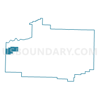
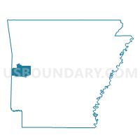
Lafayette Voting District, Scott County, Arkansas
About
Outline

Summary
| Unique Area Identifier | 528095 |
| Name | Lafayette Voting District |
| County | Scott County |
| State | Arkansas |
| Area (square miles) | 14.16 |
| Land Area (square miles) | 13.93 |
| Water Area (square miles) | 0.22 |
| % of Land Area | 98.43 |
| % of Water Area | 1.57 |
| Latitude of the Internal Point | 34.87581530 |
| Longtitude of the Internal Point | -94.40563410 |
Maps

Graphs
Select a template below for downloading or customizing gragh for Lafayette Voting District, Scott County, Arkansas


Neighbors
Neighoring Voting District (by Name) Neighboring Voting District on the Map
- Voting District 307, Le Flore County, OK
- Voting District 311, Le Flore County, OK
- Brawley Voting District, Scott County, AR
- Cauthron Voting District, Scott County, AR
- Coal Voting District, Scott County, AR
Top 10 Neighboring County Subdivision (by Population) Neighboring County Subdivision on the Map
- Heavener CCD, Le Flore County, OK (9,315)
- Coal township, Scott County, AR (214)
- Cauthron township, Scott County, AR (160)
- Brawley township, Scott County, AR (106)
- Lafayette township, Scott County, AR (78)